Jeju’s most rewarding places are spread across the island, so the right itinerary depends on where you stay and how you travel. For a first visit, prioritize Hallasan, Seongsan Ilchulbong, one coastal walking route, and either Udo or western Jeju. Add a waterfall, forest, lava tube, or museum according to the weather and your interests.
The recommendations below are selected for their geological or cultural significance, distinctive scenery, and usefulness in a first-time itinerary. Operating information was verified on June 11, 2026, but weather closures, ferry schedules, trail access, and admission rules can change.
At a glance
| Place | Best for | Time to allow | Main consideration |
|---|---|---|---|
| Hallasan National Park | Mountain hiking | 2 hours to a full day | Summit routes require reservations |
| Seongsan Ilchulbong | Volcanic scenery and sunrise | 1–2 hours | Steep staircase to the crater rim |
| Udo | Beaches and island cycling | Half or full day | Ferries depend on sea conditions |
| Jeju Olle Trail | Coastal walking | 2 hours to a full day | Routes vary in length and difficulty |
| Manjanggul and Geomunoreum | Volcanic geology | 1.5–4 hours | Check reopening and reservation notices |
| Seogwipo waterfalls | Short scenic stops | 1–3 hours | Wet steps and uneven rocks are common |
| Sanbangsan and Songaksan | Southwest coast scenery | Half day | Yongmeori Coast can close at high tide |
| Jeju National Museum | History and a rainy-day option | 1.5–2.5 hours | Closed on Mondays and selected holidays |
1. Hallasan National Park
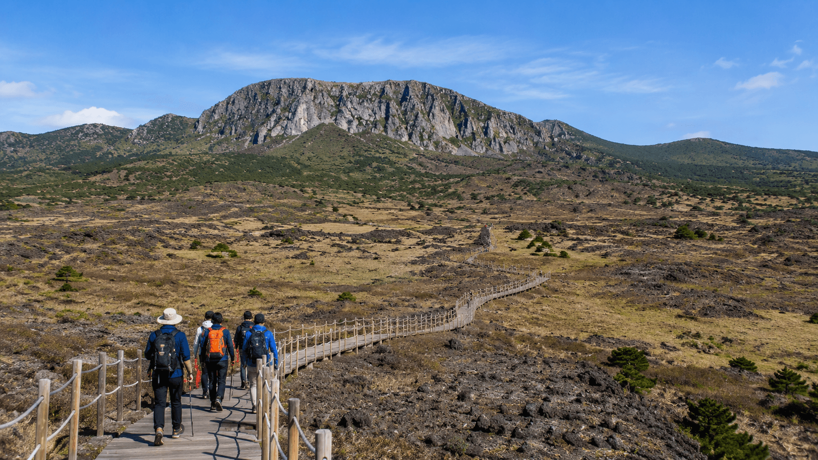
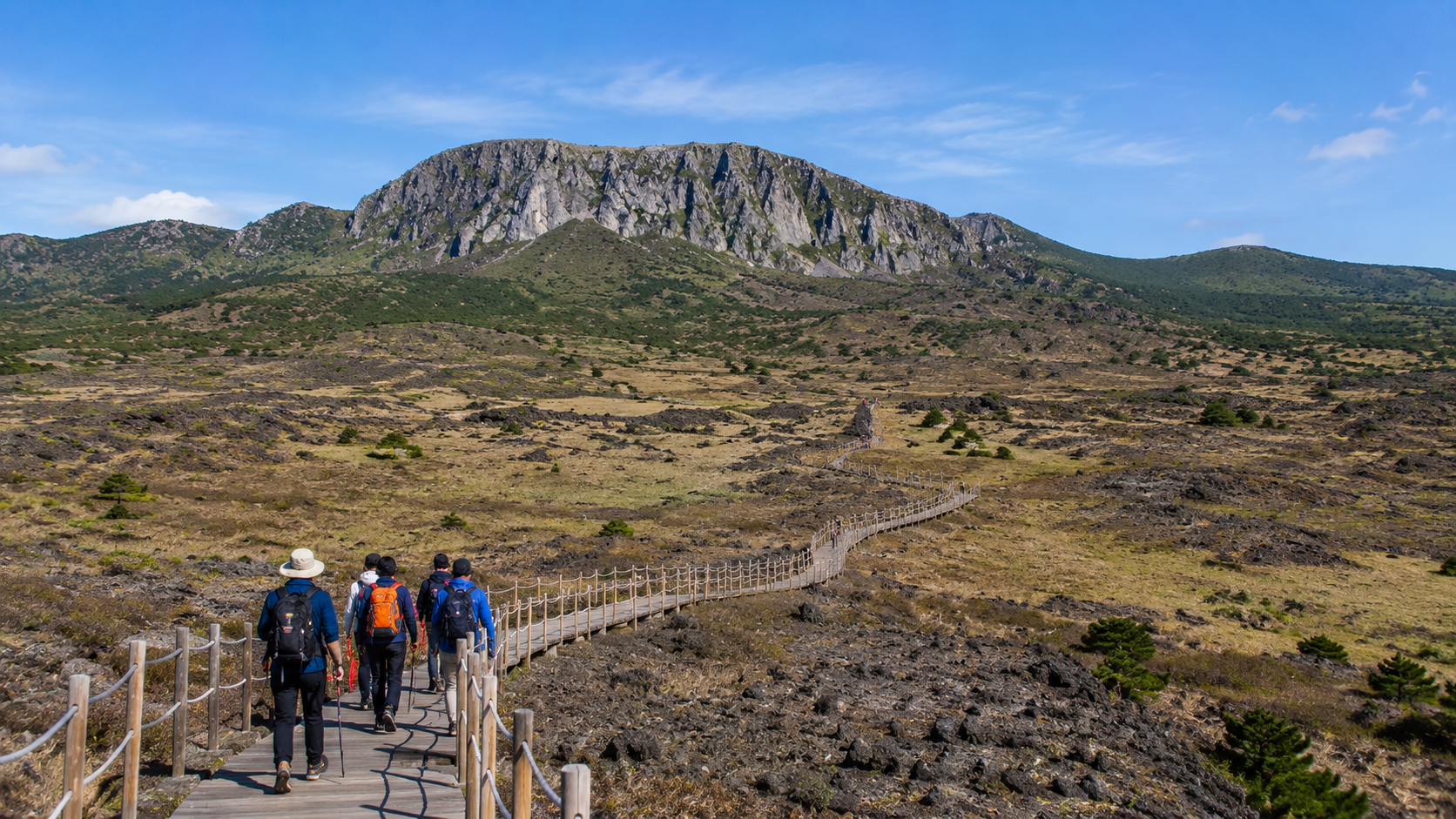
Hallasan (한라산) rises from the center of Jeju and is South Korea’s highest mountain. It is part of the UNESCO-listed Jeju Volcanic Island and Lava Tubes property, together with Seongsan Ilchulbong and the Geomunoreum lava-tube system. UNESCO describes the property as an important record of volcanic processes as well as a landscape of exceptional natural value.
You do not need to reach the summit to appreciate the mountain. Choose a trail according to your fitness, available time, and weather:
- Seongpanak Trail: 9.6 km one way, with an official estimated ascent time of about 4 hours 30 minutes to the summit.
- Gwaneumsa Trail: 8.7 km one way, with an official estimated ascent time of about 5 hours.
- Yeongsil Trail: 5.8 km, reaching Witse Oreum in about 1 hour 30 minutes and the south-wall junction in about 2 hours 30 minutes.
- Eoseungsaengak Trail: 1.3 km, with an official estimated ascent time of about 30 minutes. This is the most practical option for visitors who want a short mountain walk rather than a full-day hike.
Reservations are required for the summit routes via Seongpanak and Gwaneumsa. Use the official Hallasan reservation system and check the real-time trail information before leaving. The park warns that there are no shops along the trails, so bring enough water, food, rain protection, and suitable footwear.
Weather on the upper mountain can differ sharply from conditions at the coast. Start early, observe the seasonal turnaround deadlines, and do not build a flight or ferry connection immediately after a summit hike.
2. Seongsan Ilchulbong
Seongsan Ilchulbong (성산일출봉), often called Sunrise Peak, is a coastal tuff cone created by volcanic activity in shallow water. The official heritage authority gives its height as approximately 180 metres. Its crater, layered cliffs, and position above the eastern coast make it one of the clearest places to understand Jeju’s volcanic origins.
The paid summit route consists largely of stairs and normally takes about 20–30 minutes to climb at a steady pace. Allow longer for rests and viewpoints. Travellers who cannot manage the stairs can still see the formation from the lower paths and nearby Gwangchigi Beach.
As verified on June 11, 2026, adult admission is KRW 5,000, and the site closes on the first Monday of each month. Seasonal opening hours range from 04:30–20:00 in May–August to 06:00–18:00 in winter, with intermediate hours in spring and autumn. Ticket sales end one hour before closing. Confirm the current schedule on the official Seongsan Ilchulbong visitor page.
Sunrise is not guaranteed: eastern Jeju is frequently cloudy or windy. Seongsan is still worth visiting later in the morning, especially when combined with Udo, Gwangchigi Beach, or Jeju Olle Route 1.
3. Udo Island
Udo (우도) is a small island off Jeju’s eastern coast, reached by ferry from the Seongsan area. Its relatively compact size makes it suitable for a half-day or full-day trip involving beaches, farm roads, coastal cliffs, and views back toward Seongsan Ilchulbong.
Walking, local buses, bicycles, and electric bicycles are common ways to get around. Jeju Olle Route 1-1 circles the island and is a better choice for walkers who want a structured route rather than a series of short photo stops.
Do not treat the return ferry as a fixed urban transport connection. Sailings can be delayed or cancelled because of wind, waves, or poor visibility, and the final departure changes seasonally. Check the port notice on the day, arrive early, and leave a buffer before the last ferry. Carry your passport or another government-issued photo ID as a practical precaution and confirm the operator’s current documentation requirements.
Bringing a rental car onto Udo is restricted for many ordinary visitors, with exceptions applying in certain circumstances. Plan to leave the car near the mainland port unless the ferry operator confirms that you qualify under the current rules. Rental prices and vehicle conditions on Udo vary, so inspect brakes, tires, battery level, and insurance terms before using an electric bicycle or scooter.
4. Jeju Olle Trail
The Jeju Olle Trail is a network of marked walking routes around the coast and nearby islands. An olle is traditionally a narrow lane connecting a Jeju home to a larger road; the modern trail system uses the term for routes through villages, fields, forests, and coastal landscapes.
You do not need to complete an entire course. Useful first-time sections include:
- Route 1: Eastern fields and volcanic cones with views toward Seongsan Ilchulbong and Udo.
- Route 6: A comparatively convenient Seogwipo route connecting coastal scenery with the city.
- Route 7: A longer coastal walk passing Oedolgae sea stack and rugged shoreline.
- Route 10: Southwest scenery around Sanbangsan and Songaksan.
- Route 10-1: A short, mostly level circuit on Gapado, subject to ferry access.
Follow the blue forward arrows, orange reverse arrows, ribbons, and pony-shaped route markers. Download or photograph the latest route map because temporary diversions may not appear immediately in general navigation apps. Check current routes through the Jeju Olle Foundation and avoid exposed coastal sections during strong-wind, heavy-rain, or heat warnings.
Some routes include wheelchair-accessible sections, but this does not mean an entire course is step-free. Surfaces can change between pavement, compacted earth, boardwalk, and volcanic rock. Confirm the accessible segment before travelling.
5. Manjanggul and Geomunoreum
The Geomunoreum lava-tube system is one of the three components of Jeju’s UNESCO World Heritage property. It illustrates how lava moved from inland volcanic vents toward the coast, leaving an extensive underground network.
Manjanggul (만장굴) is the best-known publicly accessible lava tube in this system. It was closed for major safety work from December 29, 2023, and the Jeju World Natural Heritage authority posted a reopening and visitor-information notice on May 18, 2026. Because access conditions have recently changed, check the latest notice on the official Jeju World Natural Heritage website before making the trip. Wear shoes with good grip and bring a light layer: cave floors can be wet and the temperature is cooler than outside.
Geomunoreum (거문오름), the volcanic cone associated with the lava-tube system, is a separate guided or controlled walking experience. Advance reservations are required. As verified on June 11, 2026, bookings open at 09:00 on the first day of the preceding month and normally remain available until 17:00 on the day before the visit, subject to capacity. The site rests every Tuesday. Review the restrictions and book through the official Geomunoreum reservation page.
Geomunoreum does not allow unsuitable footwear such as slippers or high heels. Food, pets, and unapproved entry are also restricted. There are no toilets during the trail section, so use the facilities before check-in.
6. Seogwipo Waterfalls and Coast
Seogwipo is the most convenient base for combining waterfalls, short coastal walks, markets, and restaurants without committing to a full-day mountain route.
Jeongbang Waterfall
Jeongbang Waterfall (정방폭포) drops from a coastal cliff close to the sea. The final approach involves stairs and irregular rocks that may be slippery after rain or sea spray. It is not a suitable choice for travellers who need a smooth, step-free route.
Cheonjiyeon Waterfall
Cheonjiyeon (천지연폭포) has a gentler landscaped approach than Jeongbang and is easier to combine with central Seogwipo. It is useful for families, mixed-mobility groups, or an evening walk, although visitors should still confirm the current accessible route at the entrance.
Oedolgae and the coastal trail
Oedolgae is a sea stack west of central Seogwipo. The surrounding coast overlaps with parts of Jeju Olle Route 7 and works well for a short walk when there is insufficient time for a full course.
Waterfall volume varies with recent rainfall. Operating hours and temporary closures can also change after storms, so check individual listings through the official Visit Jeju tourism portal.
7. Sanbangsan, Yongmeori Coast, and Songaksan
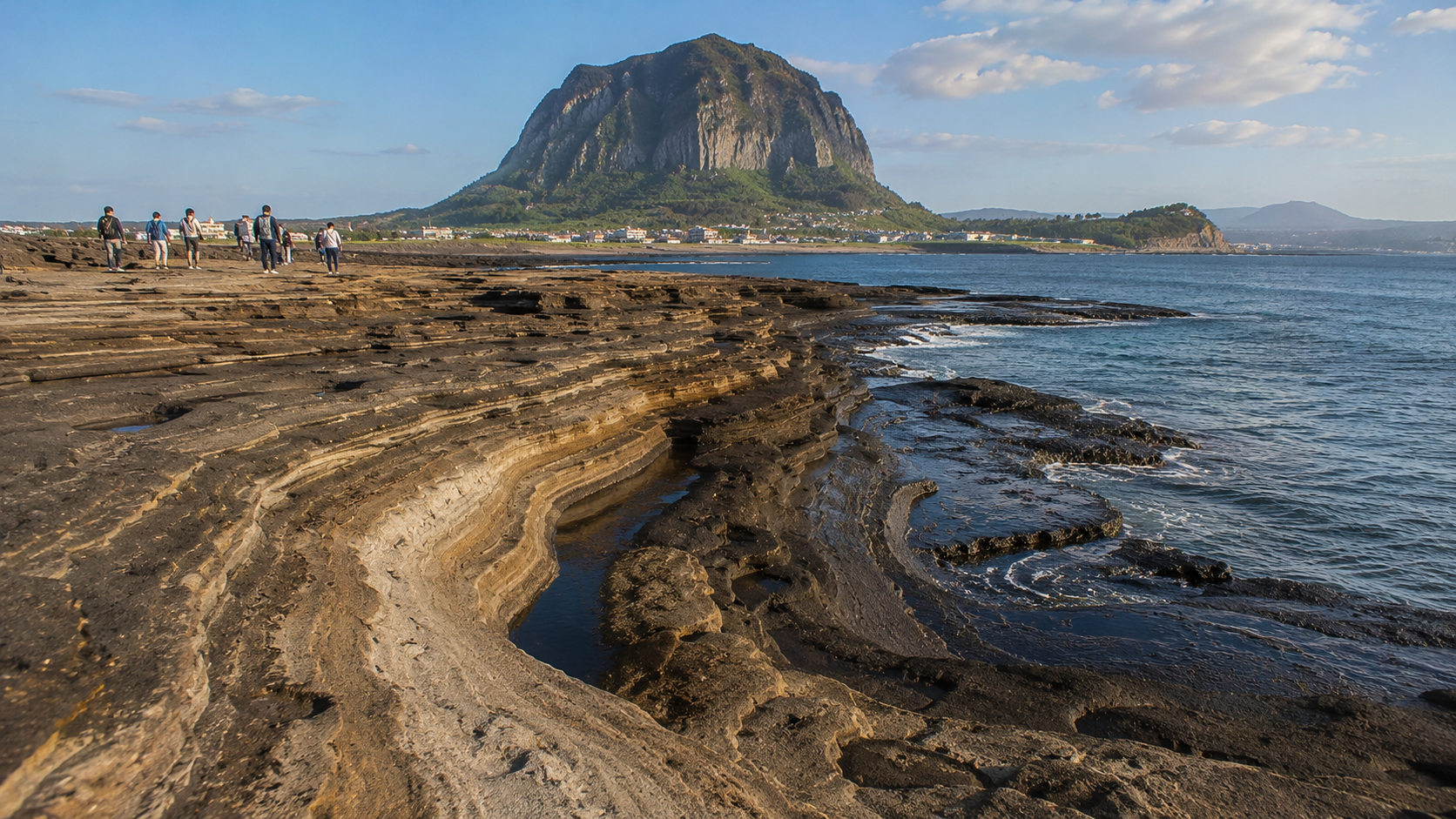
The southwest combines several landscapes within a relatively small area. Sanbangsan (산방산) is a prominent lava dome rising behind the coast, while Yongmeori (용머리해안), meaning Dragon Head Coast, exposes layered volcanic rock at sea level. Songaksan provides open coastal walking and views toward Sanbangsan, Gapado, and Marado in clear weather.
Yongmeori Coast is highly sensitive to tides, waves, and wind. Access may be suspended even when the weather appears acceptable from the car park. Treat entry as a possible addition rather than the only purpose of a long cross-island journey. Check locally before setting out and never cross a closed barrier.
A practical half-day sequence is Sanbangsan, Yongmeori if open, and a short Songaksan walk. Travellers using buses should allow extra transfer time because these sites are less convenient than central Seogwipo.
8. Jeju National Museum
Jeju National Museum is the strongest indoor choice for understanding the island beyond its scenery. Its exhibitions cover prehistoric settlement, the former island kingdom of Tamna, maritime exchange, the Goryeo and Joseon periods, and the lives of Jeju residents.
As verified on June 11, 2026, the museum is open from 09:00 to 18:00 and general admission is free, although special exhibitions may charge a fee. It closes every Monday, January 1, Lunar New Year, and Chuseok. Check the official Jeju National Museum visitor information before visiting around a Korean public holiday.
The museum is near Jeju City and is particularly useful on an arrival day, departure day, or rainy afternoon. Allow at least 90 minutes for the permanent galleries.
How to organize these places
For a stay of three or four days, group destinations geographically rather than crossing the island repeatedly:
- East: Seongsan Ilchulbong, Udo, and an eastern Olle section.
- South: Central Seogwipo, one or two waterfalls, and Oedolgae.
- Southwest: Sanbangsan, Yongmeori Coast, and Songaksan.
- Central or northeast: Hallasan, or Geomunoreum and Manjanggul.
Public buses reach major towns and attractions, but rural transfers can take time. Use the official Jeju Bus Information System for live information and verify the final return service rather than relying only on a general map estimate. A rental car provides more flexibility, but parking congestion is common at famous sites during weekends and holidays.
What to check before you go
- Check Hallasan trail status, weather, entry deadlines, and reservation confirmation.
- Confirm Udo and Gapado ferry operations on the day of travel.
- Check whether Yongmeori Coast is open for the current tide and sea conditions.
- Reconfirm Manjanggul access because it reopened following an extended closure.
- Look up the first and last bus when visiting rural or coastal sites.
- Carry a physical payment card and some KRW for small purchases or transport contingencies.
- Bring rain protection and a windproof layer even when the morning forecast is clear.
- Wear shoes suitable for wet stairs, volcanic rock, and unpaved paths.
- Avoid scheduling weather-dependent attractions immediately before a flight.
Sources
- Jeju World Natural Heritage
- UNESCO: Jeju Volcanic Island and Lava Tubes
- Hallasan National Park trail guide
- Hallasan trail reservation system
- Seongsan Ilchulbong official visitor information
- Geomunoreum official reservation information
- Visit Jeju official tourism portal
- Jeju National Museum
Start by choosing your accommodation area and one weather-dependent priority. Reserve Hallasan or Geomunoreum first, then arrange coastal and indoor stops around the forecast.